Storm Dave: A Severe Weather Alert for Easter Weekend in the UK
Introduction to Storm Dave
Storm Dave has recently been designated by the Met Office as a significant weather event impacting the UK, especially during the Easter weekend. This classification signifies the potential for severe conditions, predominantly affecting the northern regions of the country. With the arrival of Storm Dave, weather forecasts suggest the likelihood of strong gales and heavy precipitation, which could lead to hazardous travel conditions, power outages, and potential disruptions to daily life.
The naming of storms by the Met Office serves as an important communication tool, allowing the public and relevant authorities to prepare adequately for impending adverse weather. By providing a clear and recognizable name, the Met Office aims to enhance public awareness regarding the severity and urgency of weather warnings associated with Storm Dave. It is essential for residents in affected areas to stay informed about current conditions and heed any advisory notices issued by meteorological services.
Moreover, the implications of Storm Dave extend beyond just strong winds. The storm is expected to bring blizzard conditions, particularly in high-altitude regions where snow accumulation could significantly impact transportation and public safety. As the UK braces for this severe weather phenomenon, citizens are advised to take precautions, ensuring their safety and that of their families. This includes monitoring the latest weather updates, avoiding unnecessary travel during peak storm conditions, and being prepared for the possibility of home confinement should the weather become too dangerous.
As Storm Dave approaches, the focus remains on the ongoing preparations and safety measures that individuals and communities can implement to mitigate the effects of this severe weather event. Awareness and preparedness will be crucial in navigating the challenges posed by Storm Dave over the Easter weekend.
Weather Warnings Issued
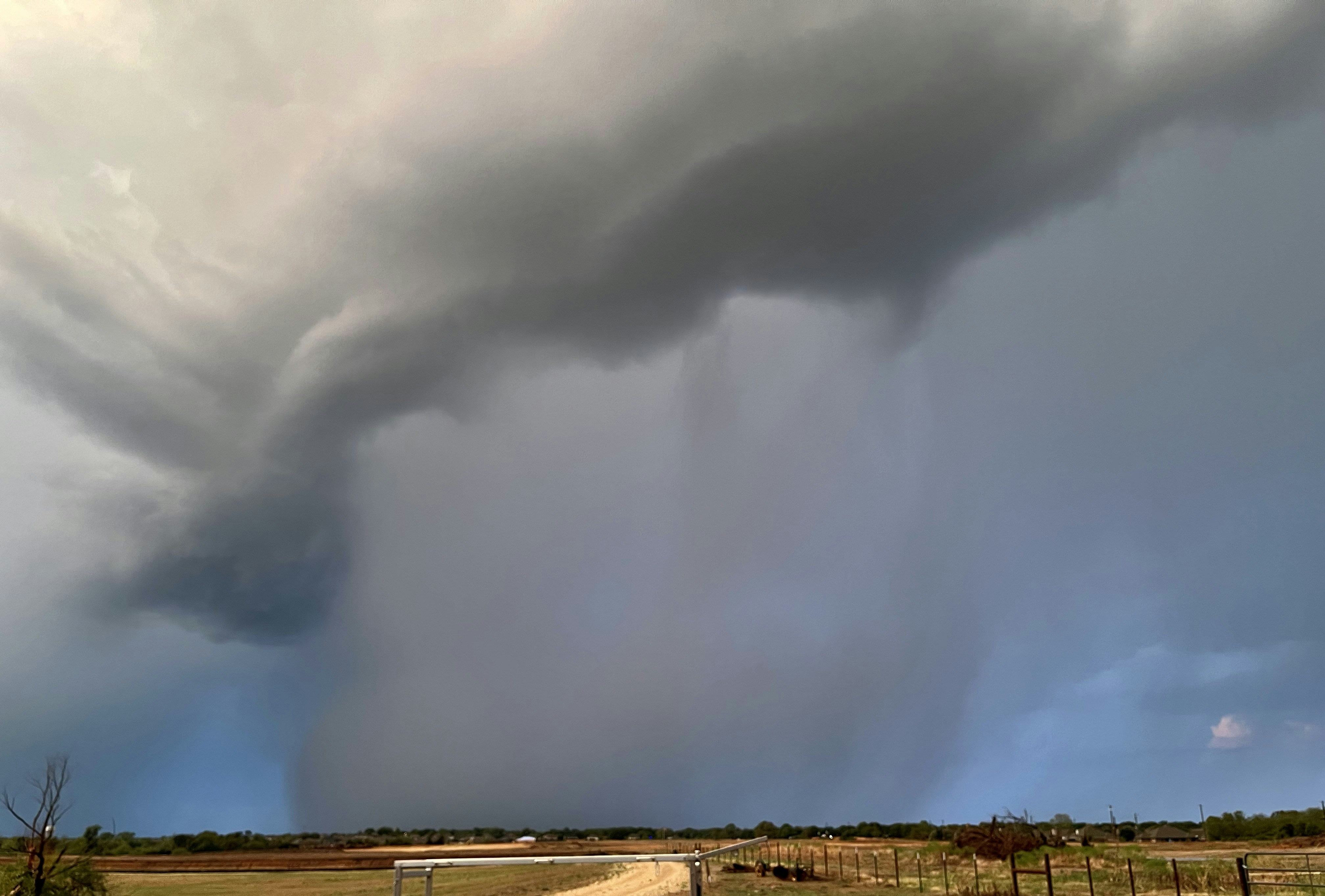
As Storm Dave approaches the United Kingdom over the Easter weekend, the Met Office has issued specific yellow warnings for wind and snow. These alerts signify that there is a potential for disruptive weather conditions affecting various regions, and residents, as well as travelers, should be aware of the implications. The yellow warning for wind is particularly concerning, with gusts expected to reach speeds of up to 60 mph in certain areas. This intensity of wind can lead to minor disruptions, such as fallen trees or debris, potentially impacting transportation networks.
In addition to the wind warning, a yellow warning for snow has also been issued, with snowfall predicted primarily in higher elevations. While significant accumulation may not be expected in low-lying regions, places at higher altitudes could see a thick layer of snow, creating hazardous driving conditions. Travel plans should be closely monitored, as delays and cancellations may occur, particularly in Scotland and northern England where the effects of Storm Dave may be most pronounced.
The issuance of these yellow weather warnings serves as a precautionary measure, urging local residents and travelers to remain vigilant. It is advisable to stay updated with the latest forecasts and heed any local authorities’ advice regarding travel and outdoor activities. Preparation is crucial; thus, individuals are encouraged to check their local news sources or the Met Office website for real-time updates on weather conditions.
Overall, the yellow warnings for wind and snow associated with Storm Dave should not be taken lightly, as the elements can pose risks to safety and mobility. Everyone is encouraged to approach the situation with caution and plan accordingly to mitigate potential impacts during the Easter weekend.
The Impact of Severe Weather
Storm Dave represents a significant weather event for the UK, particularly over the Easter weekend, when many families often engage in outdoor activities and travel. The impending storm brings with it the potential for severe consequences, ranging from property damage to power outages and substantial travel disruptions.
Historically, the UK has faced numerous storms that have resulted in widespread damage. For instance, Storm Ciara in February 2020 caused significant flooding in various regions, with damages estimated in the hundreds of millions of pounds. This illustrates the serious nature of such weather systems and the impact they can have on communities, infrastructure, and individual livelihoods.
Furthermore, during severe weather events like Storm Dave, the likelihood of power cuts increases substantially. Utility companies often prepare for potential outages by preemptively staging equipment and personnel. However, the unpredictable nature of storm damage can hinder response efforts, resulting in prolonged outages for households and businesses. During Storm Jorge in 2020, numerous areas experienced prolonged power failures, highlighting the strain on electrical grids during extreme weather.
Travel disruptions are another consequence to consider. Heavy rain, strong winds, and potential flooding can significantly affect roads, railways, and airports. For example, during Storm Keira in 2021, rail services faced cancellations and delays, disrupting travel plans for thousands of passengers. The impact is not limited to public transport; private vehicle travel may be hampered by debris and hazardous road conditions, leading to further complications for individuals attempting to navigate during the storm.
As Storm Dave approaches, it is essential for residents to remain informed of local weather alerts and to prepare for the possibility of significant disruptions in everyday life. Understanding the potential impacts of severe weather is crucial for ensuring safety and reducing risks associated with such events.
Easter Weekend Weather Overview
This Easter weekend is poised to showcase a truly dynamic and unpredictable weather scenario across the United Kingdom, particularly due to the impact of Storm Dave. Forecasts indicate a stark contrast between heavy downpours and moments of warm sunshine, which is emblematic of the transition into spring. As the storm approaches, weather patterns will fluctuate significantly, with rain showers likely to dominate the Easter Sunday celebrations.
Heavy rainfall associated with Storm Dave is projected to affect various regions of the UK, adding considerable challenge for those planning outdoor activities. The rain is anticipated to begin early on Saturday and could continue intermittently throughout the weekend. Met Office alerts warn of potential flooding in low-lying areas, particularly in western and northern regions, where the heaviest precipitation is expected. Such conditions could disrupt travel and outdoor family gatherings, necessitating precautions for those venturing outside.
On the other hand, pockets of sunshine are not entirely out of the question. After the rain subsides, temperatures may rise, particularly in southern parts of the country. This means that while visitors to parks or gardens may initially face damp conditions, there could be opportunities to enjoy brighter weather later in the day. Localised weather variations should be anticipated, as Storm Dave could cause peeks of sunshine to emerge amidst ongoing showers.
It is advisable for individuals and families to remain updated on weather forecasts leading up to Easter weekend. The combination of potential heavy rain from Storm Dave and occasional warm spells will require one to keep an adaptable approach for plans. Awareness of real-time changes in weather conditions will be key to enjoying the holiday weekend safely and pleasantly.
Understanding the Jet Stream
The jet stream is a fast-flowing air current situated in the upper levels of the atmosphere. It plays a crucial role in influencing weather patterns across the globe. Primarily located at altitudes of 6 to 12 kilometers, the jet stream can be conceptualized as a river of air that flows from west to east. Its development is linked to the temperature gradient between the polar regions and the equator, which creates a pressure difference that drives these powerful winds.
In the context of storm development, the jet stream acts as a significant catalyst. When the jet stream dips or undulates, it can create areas of low pressure, which are conducive to storm formation. These dips often lead to the convergence of warm and cold air masses, sparking the development of severe weather conditions, such as those expected during Storm Dave. Consequently, the positioning and speed of the jet stream are critical factors in determining the intensity and trajectory of storms.
Moreover, climate variations and seasonal changes can alter the behavior of the jet stream. For example, in winter, the jet stream tends to be stronger and can lead to more acute weather events. Conversely, during summer, it may weaken, leading to calmer weather. However, the complex interactions between the jet stream and local weather systems mean that predicting specific storm occurrences remains a challenge for meteorologists. Understanding these dynamics is essential for effective weather forecasting, particularly in anticipation of severe weather, such as that posed by Storm Dave.
Temperature Contrasts Across the USA and Canada
The intricate dynamics of temperature contrasts across the United States and Canada play a pivotal role in the formation and intensification of severe weather events, such as Storm Dave. These phenomena are often influenced by the interaction between cold, polar air masses descending from the north and warmer, moist air arising from the south. This clash of temperatures creates significant instability in the atmosphere, which can lead to the development of severe storms.
During the lead-up to Easter weekend, meteorological conditions have illustrated stark temperature gradients across North America. For instance, the northern states often experience frigid temperatures due to the influence of Arctic air, while southern regions bask in comparatively warmer temperatures. This stark juxtaposition not only heightens the likelihood of storm development but also enhances the power of existing weather systems.
Moreover, the positioning of the jet stream is critical in this scenario. The jet stream, a fast-flowing air current found in the atmosphere, can amplify the temperature cues prevalent in various regions. When the jet stream dips southward, it draws cold air down from the northern latitudes, while simultaneously allowing warm air to ascend from the southern parts of the continent. This tug-of-war between contrasting air masses can lead to severe weather patterns, including thunderstorms, heavy rainfall, and even blizzards in some cases.
In the case of Storm Dave, these temperature contrasts contribute not only to the severity of the storm but also to its trajectory and effects. Observing the ongoing interactions between these air masses offers valuable insight into the forecast and behavior of Storm Dave as it approaches the UK for Easter weekend.
Deep Pressure Area Approaching the UK
As the Easter weekend approaches, meteorologists have identified a significant deep area of low pressure heading towards the United Kingdom. This system, commonly referred to as a deep pressure area, is indicative of unsettled weather conditions that are likely to impact various regions across the country, starting on Saturday. A deep pressure area typically brings a number of adverse weather conditions, including increased precipitation, strong winds, and a general decline in temperature.
The meteorological term “low pressure” refers to a region where the atmospheric pressure is lower than that of the surrounding areas. This difference in pressure results in air moving toward the low-pressure zone, leading to the development of clouds and precipitation. As warmer air rises within the low-pressure area, it cools and condenses, eventually forming rain or, in more severe cases, storms. In the context of Storm Dave, this means that residents can expect a notable uptick in rainfall, potentially leading to localized flooding, especially in areas that are already susceptible due to recent weather events.
The impacts of a deep pressure area are often exacerbated by accompanying high winds, which can reach gale-force and create hazardous conditions. Coastal regions and exposed inland areas should be particularly vigilant, as strong gusts can lead to property damage, disruption of services, and dangerous travel conditions. Therefore, it is crucial for the public to stay informed about forecast updates and heed warnings issued by meteorological agencies as the low-pressure system approaches. Preparedness is key in mitigating the risks associated with severe weather brought by such deep pressure areas.
Advice for Residents and Travelers
As Storm Dave approaches the Northern UK during the Easter weekend, it is essential for residents and travelers to be prepared for potential severe weather conditions. Planning ahead and taking precautionary measures can significantly mitigate risks associated with storms. One of the first steps to consider is monitoring weather updates from reliable sources, such as the Met Office, to stay informed about the storm’s development, warnings, and safety guidelines.
Residents should assess their home’s structural integrity to ensure it can withstand strong winds and heavy rainfall. Secure any loose items in your garden or balcony that strong winds could turn into hazardous projectiles. Additionally, consider reinforcing windows and doors to prevent water ingress and structural damage. It is advised to stock up on essential supplies, such as non-perishable foods, water, medications, and candles, in case of power outages or disruptions to normal services.
For travelers, it is crucial to monitor travel advisories and be prepared for possible delays or cancellations. Aim to reschedule any travel plans if possible, especially if your itinerary includes areas that are predicted to be heavily impacted by the storm. Ensure you have flexible arrangements that allow for changes due to weather conditions. Always carry a charged mobile phone and familiarize yourself with emergency contacts and local services.
During the storm, remain indoors and avoid unnecessary travel. If you must go out, listen to local advice and avoid flooded areas. Stay away from overhanging branches or structures that may collapse in strong winds. In case of emergency, know the protocols for contacting emergency services and what to do in case of localized flooding or other hazards. Adhering to these safety tips will help protect you and your loved ones during Storm Dave.
Conclusion and Ongoing Weather Monitoring
As Storm Dave approaches the UK over the Easter weekend, it is crucial to be aware of its potential impact on weather conditions. Weather agencies have issued warnings indicating that the storm could bring heavy rain, strong winds, and some localized flooding, affecting various regions across the country. Residents are advised to remain vigilant and stay updated on any changes to the forecast, as conditions can rapidly evolve during severe weather events. The likelihood of disruptions to travel and outdoor activities is heightened, necessitating preparations to ensure safety.
It is imperative for the public to access reliable and timely information during this period. Utilizing resources such as the UK Met Office and local weather stations can provide critical updates regarding Storm Dave’s trajectory and intensity. These platforms often offer real-time alerts and forecasts that can help individuals make informed decisions, especially regarding travel plans or outdoor events. Additionally, social media channels and weather apps are excellent tools for immediate notifications and ongoing updates.
In light of the impending conditions brought by Storm Dave, understanding the vulnerabilities of your area to severe weather can prove to be essential. Home and property preparations, such as securing outdoor items and ensuring drainage systems are clear, can mitigate the impact of potential flooding or damage. By actively monitoring weather announcements and adhering to safety guidelines, communities can better navigate the challenges posed by significant weather events like Storm Dave.