Tropical Storm Barbara: Formation and Future Outlook

Photo by Ibrahim Rifath on Unsplash
The Formation of Tropical Storm Barbara
Tropical Storm Barbara originated off the southwestern coast of Mexico, where a complex interaction of atmospheric conditions enabled its development. The factors that contribute to the formation of tropical storms are multifaceted, with warm ocean waters serving as a key component. In this instance, the waters in the vicinity of Barbara reached temperatures above 26.5 degrees Celsius, providing the necessary heat and moisture to fuel the storm. Additionally, the presence of low vertical wind shear allowed the storm system to organize more effectively. This lack of disruptive wind patterns is crucial, as strong winds at differing altitudes can inhibit the growth of tropical storms.
For a weather system to be classified as a tropical storm, it must achieve sustained wind speeds of between 39 to 73 miles per hour. Initially classified as a tropical depression, Barbara intensified rapidly as it gained strength from the warm waters and favorable atmospheric conditions, officially becoming a tropical storm once it reached the requisite wind speeds. The classification is determined by the National Hurricane Center (NHC), which continually monitors developing weather patterns and tracks their progression using satellite data and advanced meteorological models.
Upon its formation, Tropical Storm Barbara was located approximately 300 miles south-southwest of Manzanillo, a significant maritime point along the Mexican coast. The geographical positioning of the storm is critical for understanding its potential trajectory and impact on surrounding areas. The NHC’s tracking efforts provided real-time updates to inform residents in vulnerable regions as well as governments, thereby aiding in preparation efforts. As the storm evolved, continuous assessments illustrated the importance of early warning systems in mitigating risks associated with tropical storms like Barbara.
Current Status and Characteristics
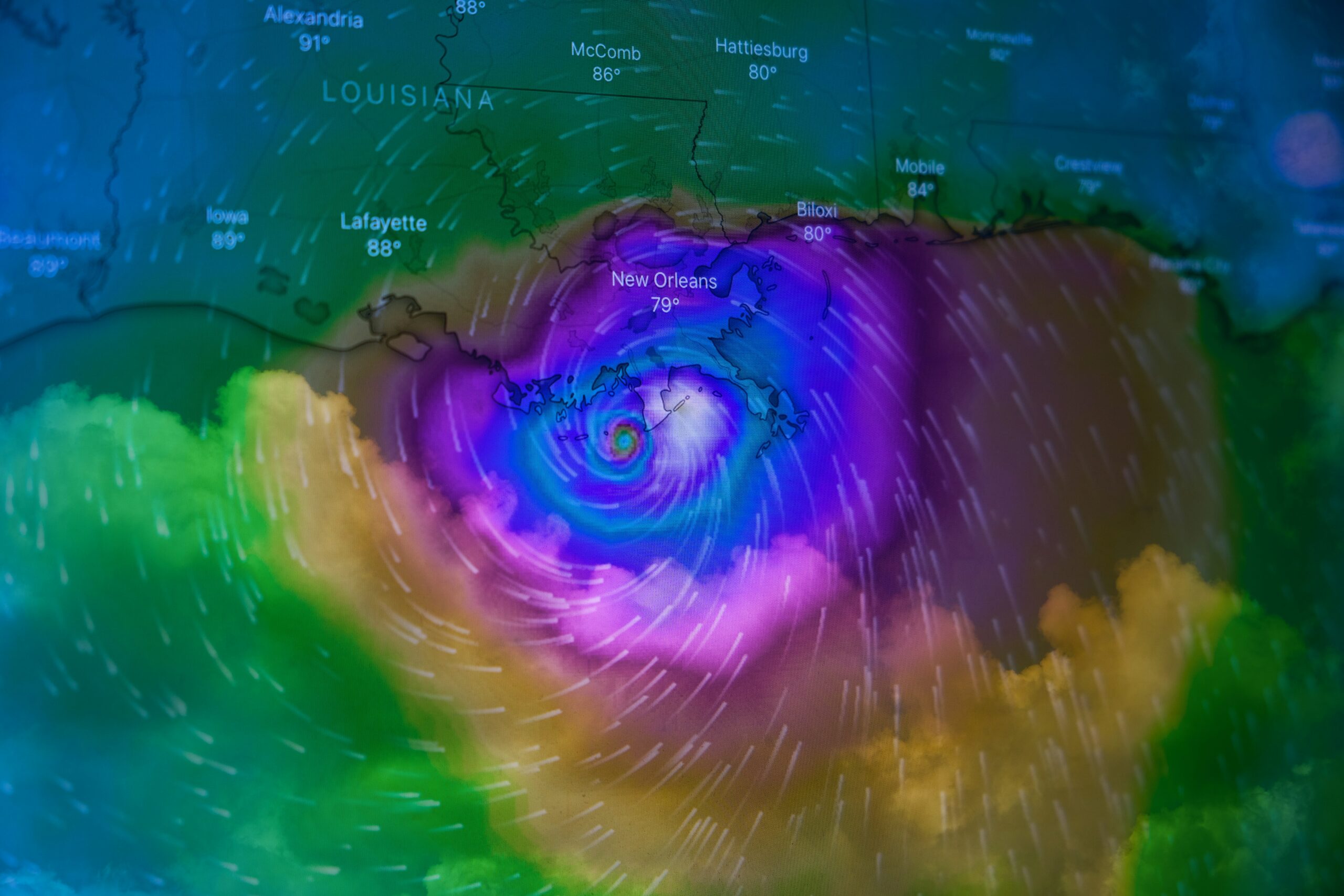
Tropical Storm Barbara has emerged as a notable weather system in the eastern Pacific, featuring maximum sustained winds of approximately 50 mph (80 km/h) as it progresses towards the west-northwest at a speed of 12 mph (19 km/h). Currently located approximately 200 miles south-southwest of Zihuatanejo, a popular tourist destination in Guerrero state, the storm is closely monitored for its potential impact on coastal areas. The trajectory indicates that the storm may bring significant weather changes in the coming days.
As the system continues to develop, its strength remains a focal point of meteorological analysis. Current models suggest that Tropical Storm Barbara could undergo additional intensification in the near future, possibly escalating its wind speeds and size. This storm possesses a well-defined low-level circulation, and examination of its structure indicates that it is organized; however, there are indications of some fluctuations in intensity that could affect its path. Sea surface temperatures in the region are relatively warm, which typically fosters further strengthening, but vertical wind shear remains a key factor to monitor in its evolution.
The storm’s position relative to significant landmarks such as Zihuatanejo is crucial for forecasting its potential impacts on local communities. Residents and tourists alike should remain vigilant as Tropical Storm Barbara moves closer to land. Preparation for potential rainfall and strong winds is advisable in anticipation of the storm’s trajectory. It is essential for affected regions to stay informed through reliable sources and follow any advisories issued by meteorological agencies to mitigate the risks associated with this developing storm.
Forecast and Expectations
Tropical Storm Barbara, currently developing in the central Pacific, has drawn significant attention from meteorologists due to its potential to strengthen into a hurricane. Recent forecasts indicate a gradual intensification of this system as it moves westwards. The projected path, analyzed through advanced models, suggests that Barbara could gain the necessary momentum to escalate into a more formidable storm over the coming days. Meteorologists employ a combination of satellite imagery, weather radars, and computer simulations to predict the storm’s future trajectory and intensity. These methodologies allow them to visualize the storm’s structure and anticipate its potential evolution.
One critical aspect taken into account in forecasting Tropical Storm Barbara is the environmental conditions surrounding it. Factors such as sea surface temperatures, atmospheric moisture levels, and wind shear are crucial. Warmer ocean waters can provide the necessary energy for the storm to strengthen, while high wind shear may inhibit its growth by tilting or displacing the storm’s structure. Meteorologists continuously monitor these conditions to adjust their predictions accordingly, ensuring that forecasts remain as accurate as possible.
Furthermore, the predictions regarding Tropical Storm Barbara highlight the importance of preparedness in affected regions. As the storm develops, communities along its projected path should remain vigilant and informed about potential changes in the forecast. The advancement of technology in storm prediction has improved the reliability of forecasts, yet unpredictability remains an inherent characteristic of storm behavior. Therefore, understanding the implications of the forecast for Tropical Storm Barbara is essential for effective emergency response and public safety. In conclusion, ongoing assessment and timely updates from meteorologists will be vital in navigating the uncertainties associated with this developing storm.
Impact and Safety Measures
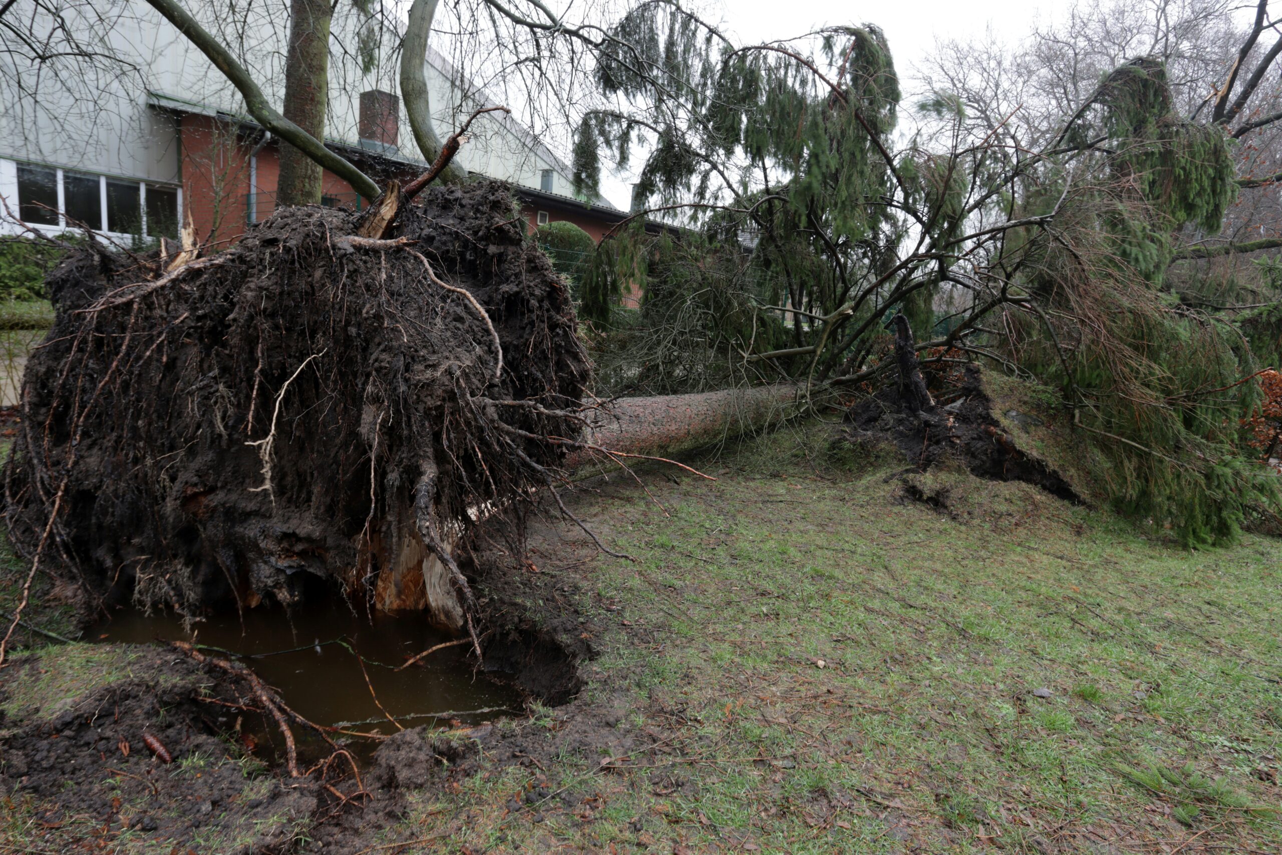
As Tropical Storm Barbara continues to develop in the Pacific, it is crucial to assess its potential impact on surrounding areas and implement necessary safety measures. Currently, there are no immediate threats to land, and the absence of coastal watches or warnings indicates that the storm is not projected to significantly affect populated regions in the near future. Nevertheless, changes in the storm’s trajectory and intensity must be closely monitored, as weather patterns can be unpredictable.
Residents and tourists in regions that could potentially be impacted by Tropical Storm Barbara should heed reports from local meteorological agencies and remain vigilant. Staying informed is vital; regularly checking the National Hurricane Center’s updates or local news outlets can provide the latest developments on the storm’s path and intensity. Emergency preparedness should always be a priority, even when the immediate risk appears low, as storms can rapidly escalate or change direction.
For those living in areas prone to flooding or high winds, it is advisable to have emergency kits ready, including essential supplies such as water, food, medications, and flashlights. Establishing a clear communication plan with family and friends is also important for coordinating safety during adverse weather conditions. Additionally, authorities in various regions may issue recommendations regarding travel and outdoor activities; heeding such advice can significantly enhance safety during Tropical Storm Barbara’s formation stage.
In light of the current information, maintaining a proactive approach towards storm preparedness is essential. Familiarizing oneself with local evacuation routes and emergency services can further ensure readiness in case the storm shifts unpredictably. By understanding Tropical Storm Barbara’s behavior and adhering to safety guidelines, communities can minimize risks and promote a safer environment for all. In conclusion, the vigilance and preparedness of residents and travelers are paramount as we navigate through this weather event.